- CNN iReport: Show us how wintry weather is affecting you.
- NEW: NFL has postponed the Minnesota-New York Giants game until Monday
- Airports are experiencing severe delays
Read more about this story from CNN affiliate KARE.
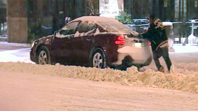
(CNN) -- Much of the upper Midwest battled blizzard conditions Saturday, with a combination of heavy snow, fierce winds and subzero temperatures pummeling the region 10 days before the official start of winter.
A blizzard warning, issued by the National Weather Service, stretched from South Dakota to Wisconsin and down to Missouri and Illinois. The storm was expected to dump between 15 and 20 inches of snow in some locales.
"It's looking very frightening," said Amrita Mukherjee of Minneapolis, Minnesota. "It's terrible. Since morning, it's been snowing heavily and the wind is really strong. And each hour, it's getting even worse."
The blizzard prompted the postponement of the NFL game between the Minneapolis Vikings and New York Giants from Sunday afternoon to Monday night, the league's website reported. The Giants were stranded at Kansas City International Airport in Missouri on Saturday, unable to get to Minnesota because of the snow, said team spokesman Peter John-Baptiste.
The storm likely will gain strength before bearing down on the Chicago area, the weather service said. Well before then, it had forced the closure of several major highways and prompted mass flight cancellations.
Scores of roads in Wisconsin, Minnesota and Iowa are closed, according to those states' transportation departments.
That includes much of Interstate 94 in the Wisconsin counties of Jackson, Trempealeau, Eau Claire, Dunn and St. Croix, with state highway authorities stating on its website that the blizzard had made that highway "impassable." At 4 p.m., local law enforcement shut down U.S. 2, near Ashland.
iReport: Treacherous conditions in Minnesota ![]()
Some 75 miles of Interstate 29 from Sioux Falls, South Dakota, south to the Iowa border were closed to all traffic as of 1 p.m., said South Dakota Highway Patrol Captain Kevin Joffer. He noted that there also was an active travel advisory on Interstate 90 in that state due to near-zero visibility.
Several roads in central and western Minnesota, including parts of Interstate 90 to the South Dakota border, also had been closed.
The Minneapolis Department of Transportation on Saturday night urged people not to travel around Minneapolis and St. Paul, according to a Twitter post by the Minnesota State Patrol.
By early Saturday evening, the state police reported 129 crashes statewide since midnight and at least 561 snow-related spinoffs -- most of them in the Twin Cities metro area.
"We're experiencing very heavy snowfall, [but] our plows are out and they holding their own," said Minnesota State Patrol Lt. Eric Roeske. "We're dealing with the problems as they occur. But it is tough getting around right now for everyone."
iReport: Massive snow in central Wisconsin ![]()
In addition, several airlines, including Delta, United, U.S. Airways and Continental announced that certain customers could change their flights, without penalty, due to the storm. While specific states and times varied by carrier, travelers to and from Iowa, Michigan, Minnesota, North Dakota, Ohio, South Dakota and Wisconsin were potentially affected.
Delta spokesperson Paul Skrbec said the airline had canceled all remaining activity into Minneapolis, one of many hubs affected by the storm. That airport was closed for more than four hours Saturday, with one runway reopening in late afternoon, said spokesman Pat Hogan.
"The big problem is snow on the taxiways and around the terminals," he said. "We are getting about 2 inches of snow per hour."
Even before the current system barreled through, Minneapolis and St. Paul, Minnesota, this season have had 16.7 inches of snow as of the first week of December. Some areas to the west and south have had even more, including 22.9 inches in Chanhassen, the National Weather Service said.
More snow came Saturday, with another 7 to 11 inches forecast through the afternoon. The precipitation should taper off by evening, the weather agency said, with temperatures dropping to 8 degrees below zero.
Some of the worst conditions in Minnesota were in the southern parts of the state, said Roeske of the Minnesota State Patrol. Blowing snow contributed to whiteout conditions, forcing authorities to temporary pull plows off the road and close several freeways.
Several people had been injured in South Dakota in accidents caused by the snow, he added, but there were no fatalities.
A blizzard warning also was in effect for most of Iowa through 9 a.m. Sunday, with the National Weather Service predicting conditions would continue to deteriorate.
Heavy Minnesota snow cancels a birthday ![]()
Between 2 and 4 inches had fallen as of 1:15 p.m., with another 5 to 7 inches expected to accumulate before the storm was done. The agency said it was expecting sustained northwest winds of 30 to 40 mph, with 55 mph gusts.
Bone-chilling temperatures were also a major concern, across the region. Wind chills -- which takes into account the wind in calculating what it really feels like outside -- were forecast, for instance, to plummet as low as 35 degrees below zero in parts of Iowa.
The storm system will continue moving east Sunday. Bruce Sullivan, a National Weather Service forecaster, said much of the East Coast states would primarily get rain, with the upper Midwest feeling the storm's bite even after it passed.
"Behind this system, it's going to turn sharply colder and very windy," Sullivan said.
No comments:
Post a Comment